Changing basemaps, Navigating the imagery slide bar, Turning on/off imagery labels


Changing basemaps, Navigating the imagery slide bar, Turning on/off imagery labels
Discovering additional information, Scale ranges for data layers, Categories for data layers
Discovering bookmarks, Adding new bookmarks
Turning on the legend, Switch from legend to data layer list
Launch a different map view
Searching for an address, Identifying search options, Searching for an intersection
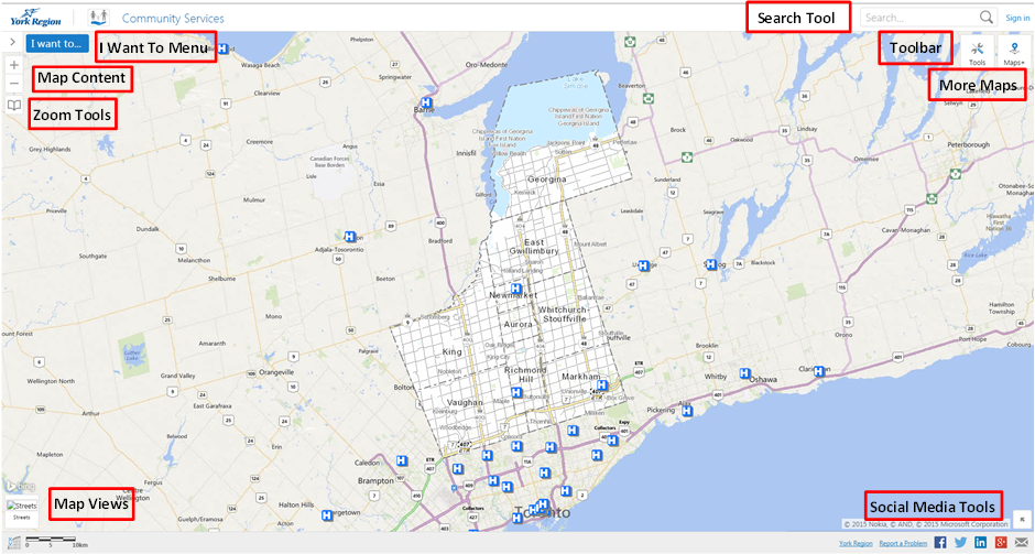
The YorkMaps interactive mapping application provides you with a simple to use mapping interface. You have access to various tools allowing for display and printing of authoritative data about York Region

Use the mouse wheel to zoom in and out of the screen. Holding down your left mouse button as you move your mouse will allow you to pan around the screen.
You'll notice, the closer you zoom into the map, the more symbols and lines start to become visible. These features include local road names, property boundaries and address numbers among others. This is done in an effort to make the map less cluttered and easier for the user to understand.

The Search Bar can be used to search for an address, an intersection or a place of interest, similar to the way common search engines are used.
Typing a key word into the search bar and pressing Enter will prompt a result window to display matching attributes.

The zoom in and zoom out tools help to change the view of your map. You can point and click on a specific area to zoom in at a fixed scale, or hold your left mouse button and draw a box to zoom in or out of.
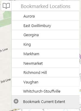
The bookmark tool allows you to save a location extent to be returned to at a later time. Yorkmaps.ca has default bookmarks for each of the local municipalities. Clicking on one of the book marks will zoom to that particular municipality.
As well, you can create your own bookmarks. Use the add bookmark option to create a bookmark once you have the view you would like to save. You'll find your newly created bookmark added to the list of pre-existing bookmarks.


This tool allows you to change the base layer of the map. The different views allow users to choose between street views, imagery view, and terrain view.
The Terrain view will display topological terrain of York Region.
The Imagery view will display orthophotography (air photos) of the Region. Within this view users have access to the Historical Imagery slider.

The historical imagery slider allows users to change the imagery within the view to different years between 1970 and the present.

The Maps+ menu allows users to navigate between different themed maps. Each of the different maps contains features and information specific to the maps theme.
Some of the views include:

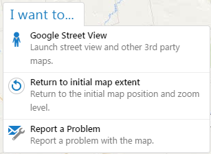
This menu allows you to launch other tools including Google StreetView as well as Report a Problem.
Report a Problem:
The report a problem tool allows you to give feedback to York Region if you notice any problems on our maps.
You can provide general feedback, or include a location if your problem is location specific

One of the features that makes YorkMaps unique when compared to other web mapping applications stems from the variety of mapping tools that are directly built into it. Clicking on the Tools button in the upper right corner will open the tools available to you. Hovering your mouse over the individual tools will identify what each tool is.
The different points, lines, and polygons on the map are representations of different geographic features located in York Region. These features may represent schools, emergency services, land use, trails, different facilities etc.
Clicking on a symbol will open a menu with information associated with that feature. This is what really allows the users to take advantage of the GIS technology.
All the map information within York Region's boundaries is supplied by the Data, Analytics and Visualization Services Branch and various other data provided from authoritative sources. YorkMaps provides authoritative data for York Region, users will find the most reliable and up to date information relevant to geographic features within the Region's boundaries.
The information for areas outside of York Region's boundaries is supplied by ESRI Inc.
There are pre-determined symbols turned on by default when the map loads, as well as others that can be turned on manually through the Map Content dropdown menu.
Clicking on the arrows beside each feature will expand or contract the features within each category that are available to be switched on and off.
Check the box next to the features that you wish to turn on or off.

The Maps+ menu allows users to navigate between different themed maps. Each of the different maps contains features and information specific to the maps theme.
Some of the views include:
When switching between maps users may be prompted to sign in with as user name in password. This is because the map that is attempting to be accessed is a secured view and restricted to the public. York Region employees will gain access by entering their Regional username and password.

The Following list summarizes the currency of YorkMaps base map data. Please direct all questions or comments to data@york.ca